How Ukraine's Modern Borders Took Shape
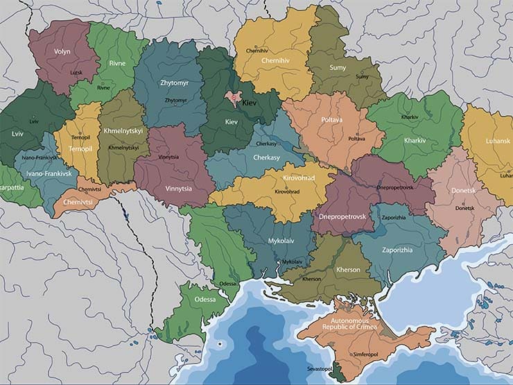
A colorful map can make Ukraine look like a collection of territories handed over by neighboring rulers. It's an appealingly simple picture—and a bad way to understand how the country's modern borders were formed.
Borders in Eastern Europe moved through wars, imperial collapse, treaties, Soviet decisions, deportations, and, finally, a nationwide vote for independence. None of those events turned today's internationally recognized borders into a menu that another country can reopen by force.
Before There Was a Modern Border
For centuries, lands inhabited by Ukrainians sat inside several states and empires. The Polish-Lithuanian Commonwealth, Russian Empire, Habsburg monarchy, Ottoman Empire, and Crimean Khanate all controlled different areas at different times.
Those political borders rarely matched language, religion, or identity cleanly. Cities such as Lviv, Chernivtsi, Uzhhorod, Odesa, and Sevastopol developed layered Ukrainian, Polish, Jewish, Romanian, Hungarian, Crimean Tatar, Greek, Russian, and other histories.
That matters because a region's former ruler isn't the same thing as its permanent owner. If it were, almost every border in Europe could be contested with a sufficiently old map.
Revolution, Independence, and Soviet Ukraine
After the Russian Empire collapsed in 1917, Ukrainians created the Ukrainian People's Republic and fought for an independent state. Several armies and governments competed across the region before Bolshevik forces prevailed, and the Ukrainian Soviet Socialist Republic became one of the founding republics of the Soviet Union in 1922.
Its early boundaries changed more than once as Soviet authorities reorganized territory. These were administrative decisions inside a dictatorship, not free negotiations among populations.
Western Ukraine and the Second World War
Between the world wars, Galicia and western Volhynia lay within Poland. In September 1939, Nazi Germany invaded Poland from the west and the Soviet Union invaded from the east under the secret arrangements of the Molotov-Ribbentrop Pact.
The Soviet Union absorbed eastern Polish territories into Soviet Ukraine and Soviet Belarus. The Polish-Soviet border was revised and formalized after the war, leaving Lviv and much of western Ukraine within the Ukrainian SSR while Poland shifted west.
Saying “Poland was given to Ukraine” erases too much. It hides the Nazi-Soviet partition, occupation, mass violence, forced population transfers, and the fact that these borderlands had never belonged to only one people.
Bukovyna and Bessarabia
In 1940, the Soviet Union forced Romania to surrender northern Bukovyna and Bessarabia. Northern Bukovyna, including Chernivtsi, and part of Bessarabia went to Soviet Ukraine, while much of Bessarabia became the Moldavian SSR.
Romania retook the area during the Axis invasion of the Soviet Union, and Soviet rule returned in 1944. The postwar settlement left northern Bukovyna and southern Bessarabia inside the Ukrainian SSR.

- Traces Ukraine from its earliest history through the modern independent state
- Explains why Kyiv stands at the center of the Eastern European story
- A strong foundation for understanding Ukrainian identity, borders, and politics
Zakarpattia
Zakarpattia, also called Transcarpathia, belonged to the Habsburg realm before becoming part of Czechoslovakia after the First World War. Hungary occupied it during the Second World War.
In 1945, Czechoslovakia and the Soviet Union signed a treaty transferring the territory to Soviet Ukraine. Its history remains visible in the region's Ukrainian, Rusyn, Hungarian, Slovak, Romanian, Jewish, and Roma heritage.
Crimea and the 1954 Transfer
Crimea was transferred from the Russian SFSR to the Ukrainian SSR in 1954 through formal Soviet state procedures. The official reasoning cited economic links, geographic proximity, and close ties between Crimea and Ukraine, while the transfer was also presented as marking the 300th anniversary of the Pereiaslav agreement.
It wasn't Nikita Khrushchev casually giving away a private possession. Both republics were inside the Soviet Union, and the peninsula's water, energy, rail, and supply systems were closely connected to mainland Ukraine.
The usual “gift” story also omits the people who paid the highest price. Soviet authorities deported the entire Crimean Tatar population in 1944, along with other minorities, and many Crimean Tatars weren't able to return until the final Soviet decades.
The Encyclopedia of Ukraine's history of Crimea provides useful background on the peninsula before and after 1954.
The Vote That Made the Border International
When the Soviet Union was collapsing, Ukraine held an independence referendum on December 1, 1991. Nationwide, 90.32 percent voted yes, and every region recorded a majority for independence, including Crimea and Sevastopol.
That vote transformed the Ukrainian SSR's republican boundary into the border of a sovereign state. Russia later recognized Ukraine's sovereignty and existing borders in agreements including the 1994 Budapest Memorandum and the 1997 Treaty on Friendship, Cooperation, and Partnership.
This distinction is crucial. The legitimacy of modern Ukraine doesn't rest on whether a tsar, general secretary, or medieval prince once controlled a particular city; it rests on independence, popular consent, international recognition, and international law.
What Russia's Annexation Claims Changed
Russia occupied Crimea in 2014 and declared it annexed after a vote held under military occupation. It then attempted to annex Donetsk, Luhansk, Kherson, and Zaporizhzhia regions in 2022, even though it didn't control all of those territories.
Those declarations didn't legally redraw Ukraine. In October 2022, the United Nations General Assembly condemned the attempted annexations by a vote of 143 to 5 and reaffirmed Ukraine's territorial integrity within its internationally recognized borders.
Occupation describes who controls land at a given moment; sovereignty describes whose territory it remains under international law. Confusing the two rewards military force with a legitimacy it doesn't create.

- Travels through the borderlands where empires repeatedly reshaped Ukraine
- Connects Kyiv's story with Crimea, Lviv, Odesa, and the wider region
- A narrative history for readers who prefer people and places to timelines
A Better Way to Read the Map
Ask what process changed each boundary, who was able to consent, and who was displaced or silenced. Then separate historical rule from modern sovereignty.
Ukraine's borders carry the marks of empires and Soviet power, just as borders across Europe do. Their history is complicated, but the present principle is not: no old map gives a neighboring state the right to invade and redraw them.